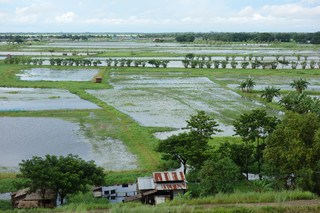
Agricultural land in Nyaungdone Township, as in other areas in the Ayeyarwady (Irrawaddy) delta, is divided into two distinct classes: alluvial land also known as kaing land located outside the river flood protection embankments; farm land within the flood embankment. Kaing lands are farmed along river banks during the dry season and are normally under water during the monsoon period. Pre-monsoon and post-monsoon crops, including groundnuts, pulses, chilies and vegetables are notably found along the narrow strips mostly occurring along the Irrawaddy River. These soils are generally very fertile but also unstable owing to the dynamic accreting and eroding land. Farming activities (or kaing cultivation) is therefore uncertain and cropping patterns move according to the shifting boundaries of the land both in space and time.
U Kyi Tin is a 50-year-old farmer living in Gaw Tu village in the township of Nyaungdone. The village of Gaw Tu is located near the banks of the Irrawaddy River and farmers from the area have traditionally been able to cultivate during the rainy season, notably beans on lands which are yet classified as kaing land by the Land Department, Ministry of Agriculture, Livestock and Irrigation (MoALI) (owing to the fact that they are located outside the embankments). U Kyi Tin use to cultivate beans starting from late August or September. The farm lands in the village are generally flooded once during the rainy season and farmers start ploughing and sowing when the waters start receding. In the last three years, however, the water levels of the Irrawaddy River have reached critical levels, resulting in prolonged submergence of the kaing lands. According to local villagers, the increased level of water in the Irrawaddy River is associated to deforestation and increased rainfall patterns occurring in the upper part of the Irrawaddy Basin. Some villagers also point out that the shifting flood patterns owe to changes in the direction of the water flow in the River. Some areas in Nyaungdone Township which were previously intensely affected by submergence are indeed being spared while others become increasingly affected by the floods.
The uncertainty of flooding for farmers in Gaw Tu is a matter of anticipating the number of rise of water. As U Kyi Tin emphasizes, “three years ago our village was flooded only once during the rainy season, the water comes in July and recedes in August and it has been so for decades”. In 2016” the water came twice but within a short period of time and the gap between the two rises of water was short but this year, there have been more than 20 days between the first and second rise of water and we are expecting a third rise in the next days.” In Gaw Tu village, many farmers have been surprised by the second rise of water and have seen their crops planted after the first wave completely destroyed. Farmers are hence put in a position of speculating and waiting for the next rise of water, where the ‘next’ can be tomorrow as much as never. Cropping activities are suspended to the uncertain movements of the Irrawaddy River and require farmers to have more flexibility in their cropping, watching, actualizing, making sense of and/or risking.
This raised important questions concerning the relations between agricultural decision making and action under certainty and uncertainty. What is to decide in an uncertain and open context? How are the choices and actions (anticipation, adaptation, resistance, etc.) of cropping and not cropping informed? Uncertainty which has become an inflating concern in many social and ecological contexts is it solely a source of anxiety? Uncertainty also means that everything is possible, the beginning as well as the end, the best as the worst. The question of the ‘possible’ hence becomes a nagging one. In the case of the kaing land, it also shed light on the concern of uncertainties, intuition and creativity.

